I lived in Lexington, KY, for two years. I've flown out of Lexington-Fayette airport who knows how many times, often on the same Comair flight 5191 that
crashed today just a half-mile from takeoff in western Fayette County. (I also have a private pilot's license, which, I must say, I haven't used in a long time -- but I am familiar with the terminology.)

Almost immediately, something about the Lexington, Kentucky, plane crash and the details of the recovery operation seemed to indicate that the aircraft, a Bombardier CRJ 200, had taken off from the wrong runway. (For a Google Map of the airport, click
here; the map to the right comes from
fltplan.com.) The longer of the two runways (7000 ft long) handles all of the jet traffic. It goes southwest to northeast.
Since midnight last night, the prevailing winds have been out of the south and then the southwest. Because all aircraft have a easier time taking off in the space allotted if they take off into the wind, Comair 5191 would surely have been scheduled to takeoff on runway 22 (rather than runway 4); that is, toward the southwest on the long runway.
It is very unlikely that a jet aircraft would have attempted to take off from runway 26, except by accident, because the runway is too short. According to
Flug Revue, the Bombardier CRJ 200 requires at least 1700 m, or 5800 ft, for takeoff. Anything shorter than that, and the aircraft would be forced to takeoff with help of what is known as "ground effect" without the velocity needed to sustain lift at elevations more than a hundred feet above the runway surface.
The pilots were veterans with Comair, which means that they had surely flown in and out of Lexington-Fayette any number of times. Both the pilot and co-pilot would have known which runway they were on before they took off. Furthermore, the control tower at Lexington-Fayette operates continuously (that is, there's someone there 24 hr a day). They would have been an additional impediment to mis-directed takeoff.
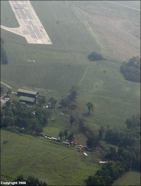
And yet, where did the rescue crews go? According to images from the local ABC/CNN affiliate, vehicles were accessing the crash site from somewhere near the intersection of Rice Rd (which heads north-south along the western edge of the Keeneland Racetrack grounds) and Versailles Rd, which heads east-west between Lexington and Versailles,
roughly parallel to runway 26. The
Lexington Herald-Leader reports that the aircraft crashed 1/2 mile from the end of the runway. Going back to the Google Maps image (
here), if you were to try to access a crash site 1/2 mile from the end of runway 22 (the long runway), you would go to Parkers Mill Rd (KY Rte 1968), which is nowhere near where the vehicles were coming and going.
I have to conclude from this that there is a better than even chance that both pilots and the control tower failed to notice that the plane was taking off from runway 26. I find this completely surprising, and also really, really hard to believe, but I just don't understand, otherwise, why rescue and police vehicles would be using Versailles Rd, and not Parkers Mill Rd, to get to the crash site.
UPDATE: One blogger, worried about terrorism, lets this crash lead her into
a complete psychotic break.
[Note that this blogger,
Stacy Harp, is now threatening me with a libel suit for my comment that she was insane to jump to the rash conclusion that Muslims brought down the plane when it was so clearly pilot error. As a show of good faith, I am more than happy to state here, in front of everyone, that I have no way of knowing whether Stacy Harp is undergoing a psychotic break, and that the statement was meant solely to reflect the impression I got from the complete irrationality of her blog post that she was not thinking clearly.
This is the most protected kind of speech under the First Amendment, especially since it was in no way meant to defame the character of Ms. Harp or harm her personally or professionally in any way. Blogs are meant to spread ideas and concepts -- and often in colorful and original ways. I found her ideas to be utterly bankrupt, and therefore took the step of publicly stating just how bankrupt I thought they were, just as she publicly defamed all Muslims by assuming that they would be responsible for the crash. So far, she has not provided a reasoned rebuttal to my claim that she was premature in assuming that Muslims caused Comair 5191 to go down. Personally, I think she owes the families of the passengers, and Muslim Americans living in the Lexington area, an apology. If she, or her attorney, wishes to send me another email concerning the content of this post, then they are more than welcome to do so. Perhaps the American-Arab Anti Discrimination Committee will contact her. Of course, I wish her no personal harm, but we are all grownups here. Not all responses to blog posts, such as
hers, will be applause.]
UPDATE II: Sean Osborne from the Northeast Intelligence Network (I'm not familiar with this organization) is
partial to the "wrong runway" hypothesis [emphasis mine]:
Based upon my carefull review of Bomardier CRJ-100 regional jet specifications, and having seen a live streaming video feed from a Lexington, Kentucky television station, as well as detailed satellite composite imagery of the Bluegrass Airport, it seems certain and is my assessment that Comair Flight 5191 executed its takeoff from the incorrect runway.
Facts I cite in making this assessment are as follows:
The ground impact markings and final site of the aircraft on the ground are consistent with an east to west departure from Runway 22/8.
Comair Flight 5191 impacted the ground a very short distance and in a straight line from the end of Runway 22/8, which on its western end is designated as runway 8 and is the nearest point to the impact site.
The length of this runway, which appears to be undergoing improvements of its surface, is approximately 3500 feet.
The primary runway at Bluegrass Airport, Runway 22/4, is 7,000 feet in length.
The CRJ-100/200 family of regional jet aircraft require a minimum takeoff distance of approximately 5,000 feet.
UPDATE III: A
local farmer, Nick Bentley, confirms the "wrong runway" hypothesis (Lexington Herald-Leader). According to
Scott Lanter, the Airport fire chief, the crash site is in line with the shorter runway 26.